Explore Rillington
The History of Rillington, North Yorkshire
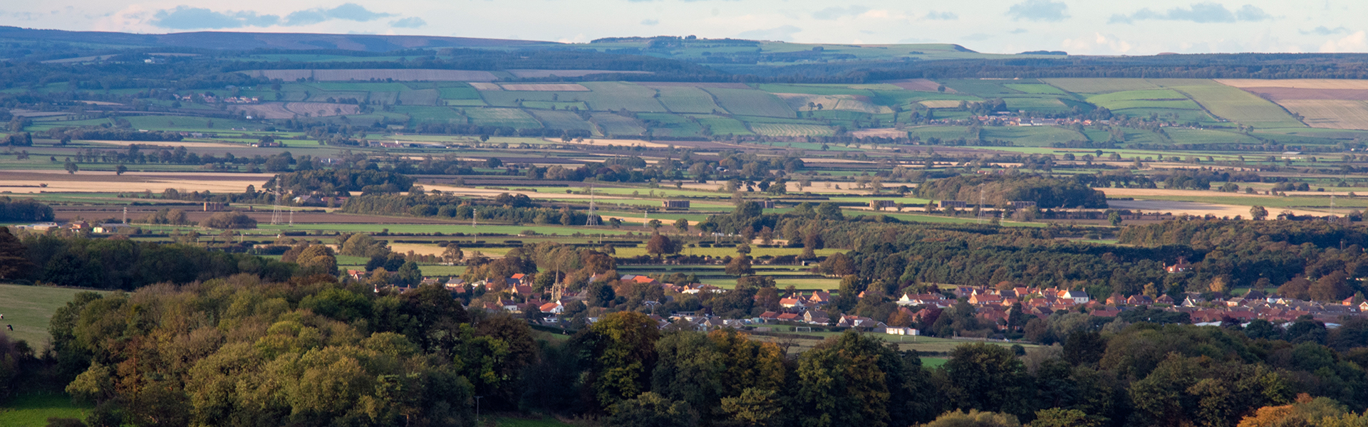
Rillington, nestled in North Yorkshire along the A64, boasts a rich history of bygone eras. With a population of 1,205 as per the 2021 census, this charming village is embraced by the River Derwent to the north. Located at the edge of the Yorkshire Wolds, it benefits from ancient glacial deposits from the former Lake Pickering, sustaining a vibrant farming community.
Before 1974, Rillington spanned both the East and North Ridings of Yorkshire. The parish of Rillington was administratively in the former Buckrose Wapentake on the border of the East Riding of Yorkshire comprising the township of Rillington and the chapelry of Scampston with their mutual history inextricably linked.
While modern travellers today may breeze through, the village once held pivotal importance at the crossroads, extending northward along Low Moorgate, weaving history with every step toward the railway and the farmlands beyond.
An Exploration of Rillington’s Long History and Ancient Parish
Delve into Rillington’s ancient past, where Iron Age settlers left their mark with a fascinating square barrow cemetery, revealing pottery and metalwork that whisper tales of times long past.
From the seismic Norman Conquest to the transformative Railway Revolution, witness the village evolve with each era. Monasteries find new purpose, unused land is transformed into thriving farms, and a bustling railway hub emerges, forever altering Rillington’s future.
Five Epochs of Transformation:
| 1066: The Norman Conquest | Experience the upheaval of the Norman Conquest, an eleventh-century invasion that reshaped Rillington’s destiny. King William I’s ambitious “Great Survey” in 1086, known as the Domesday Survey, meticulously documented land and landholding, forever altering the course of history. Meet the descendants of the invaders, the St. Quintin family of Scampston Hall. |
| 1536: The Reformation and Dissolution of Monasteries | Journey through Tudor England as the Reformation sweeps the nation. Monastic lands and buildings find new purpose in the hands of families aligned with King Henry VIII’s break from the Catholic Church. Witness the transformation of Byland Abbey, whose stonework and lead contributed to the fabric of Rillington’s history. |
| 1641: The Birth of Low Moor | Witness the birth of Low Moor, a ground once deemed wasteland, now transformed into thriving farms thanks to the vision of Philip Wheath. |
| 1780: Fields Enclosed, Future Defined | As the 18th century unfolds, the landscape of Rillington undergoes a second enclosure, revolutionising the way food is produced to sustain a growing population. |
| 1845: The Railway Revolution | Feel the pulse of change as the York and North Midland railway bridges the gap, shattering Rillington’s isolation. Nestled at the crossroads of vital lines, this railway hub serves as a lifeline for the burgeoning tourist industry along the coast and facilitates the efficient movement of goods across Yorkshire. Witness the rise of a bustling station, accompanied by the birth of housing, industries, and an era of progress. |
Rillington’s Past: A Timeline Through the Ages
Rillington, a village nestled in North Yorkshire, has seen centuries come and go, cementing a legacy of resilience, change and progress.
Hudleston described Rillington as an ‘everyday village’, though it was much more than that. This timeline captures some key events and some of the people who settled here and made it their home and community – from ancient monuments to modern transformations, every entry is a snapshot of Rillington’s rich history.
Iron Age: Ancient Barrow Cemetery
In East Field, an ancient monument of national significance stands as a testament to pre-historic settlers. The square barrow cemetery, adorned with remnants of pottery and brooches, whispers tales of a time long forgotten.
Eleventh Century– King William the Conqueror’s 11th Century England
| 1066 | Domesday Book | Lord Gilli and Earl Mortain owners |
| 1086 | Domesday Book | King William I, Tenant -in-Chief, owners |
Twelfth Century – The Norman’s Land
| 1150 | St. Andrew’s Church, Westgate and Low Moorgate built Norman and early English. Grade I listed building |
| 1180 | Monks of Byland Abbey were granted St. Andrew’s Church |
Thirteenth Century -Of Monks and Rectors
| 1230 | Robert de Okham, rector |
| 1230 | Adam de Evesham, rector |
| 1236 | Philip de Waderesby, rector |
| 1267 | Walter Baret, rector |
| 1272 | Richard de Lanceford, rector |
| 1272 | Henry de Menyll, rector |
| 1293 | John, son of Walter de Brayton, rector |
| 1297 | Yorkshire Lay Subsidy listing 10 surnames |
Fourteenth Century – of Surnames and Subsidies
| 1304 | William de Yarewell, rector |
| 1314 | John de Lutton, rector |
| 1314 | John de Seleby, rector |
| 1325 | Richard de Cave, rector |
| 1331 | Thomas Dryffeld |
| 1346 | Adam de Barneby, vicar |
| 1353 | Peter de Askelby, vicar |
| 1354 | Peter de Wetewangs, rector |
| 1364 | Roger Pye, vicar |
| 1381 | Assessment for Poll Tax listing 24 surnames |
| 1385 | John de St. Ivone |
Fifteenth Century – the Vicars of Rillington
| 1405 | Richard Broker, vicar |
| 1427 | Richard Baynton, vicar |
| 1427 | John Dronsfield, vicar |
| 1451 | John Foston, vicar |
| 1473 | Laurence Fotherley, vicar |
| 1479 | Richard Helmesley, vicar |
Sixteenth Century- Clergy and Surnames
| 1510 | Rillington and Scampton Manor Court listing 50 surnames |
| 1518 | Richard Barker, vicar |
| 1525 | William Burton, vicar |
| 1528 | John Bell, vicar |
| 1536 | Dissolution of the Monasteries |
| 1545 | William Abbot, vicar |
| 1552 | St. Quintin family established at Scampston |
| 1571 | Robert Lambe appears – Lamb Lane is named after the family |
| 1572 | William Pecket, vicar |
| 1575 | James Locksley, vicar |
| 1582 | Edmund Watson, vicar |
| 1593 | Laurence Devys, vicar |
17th Century: Rillington in Transition
| 1600 | Rectory Farmhouse, Low Moorgate. Grade II listed building |
| 1604 | William Bardon, vicar |
| 1614 | William Burton, vicaraPhilip Wheath, rector of Hinderwell appears |
| 1616 | Alexander Bardon, vicar |
| 1620 | Sir Richard Etherington, Levisham acquired the Rectory and tithes |
| 1637 | John Starr, vicar |
| 1639 | English Civil War |
| 1640 | Enclosure (1) Low Moor encouraged by Philip Wheath |
| 1642 | Humphrey Melton, vicar |
| 1661 | Maister Wheath & Maister Etherington were the two leading men in the village |
| 1661 | Richard Gowland, vicar |
| 1672 | Yorkshire East Riding Hearth Tax 1672-3, Buckrose Wapentake listing 64 surnames |
| 1676 | Compton Census – Ancient an ecclesiastical survey to establish inhabitants, papists and dissenters |
| Late C17 1693 | Church Farmhouse, Westgate. Grade II listed building Peter Phillips, curate |
| Late C17 | Scampston Hall. Grade II listed building |
18th Century: The Flourishing Epoch of Expansion
| 1700 | Manor of Scampston acquired by the St. Quintin family. Hall built |
| 1703 | A Friends’ burial place was noted in notes of a meeting in Malton. Local lore suggests it was behind the Coach and Horses |
| 1714 | Winds blew the church steeple off – Rev. Phillips |
| 1720 | Black servant boy of St. Quintin’s baptised as John Scampston |
| 1725 | John Scampston buried |
| 1726 | John Rudd, curate |
| 1730 | Low Moor brickyard |
| 1743 | Rillington had 50 families and a dame school. Scampston had 25. No dissenters |
| 1750 | Holly House Low Moorgate. Grade II listed building |
| 1750 | The Coach and Horses Public House, Low Moorgate and Scarborough Road. Grade II listed building |
| 1757 | Park View, Low Moorgate. Grade II listed building |
| 1775 | John Cook, vicar |
| 1780 | Enclosure (2) of East and West Fields |
| 1783 | Rillington Poor House erected in time for Christmas |
| 1783 | The weathercock and part of the steeple were blown down – Rev. Cook |
| Late C18 | 3 Westgate, formerly a vicarage. Grade II listed building |
| Late C18 | Manor Farmhouse, Breckney Lane. Grade II listed building |
| Late C18 | Park Farmhouse, Low Moorgate. Grade II listed building |
19th Century: A Century of Great Change
| 1802 | James Carter Green, vicar |
| 1805 | Wesleyan chapel erected. |
| 1818 | Congregational/Independent Church (Bethesda Chapel) Grade II listed building |
| 1821 | Rillington Workhouse was the centre of a Gilbert Union which included up to 50 parishes |
| 1830 | Allotments known as the Sands/Canadas helped alleviate the bad effects of enclosure |
| 1831 | Edmund Day, vicar |
| 1835 | John Dufton, vicar |
| 1836 | First notes from a Jury Book elects William Collinson to replace the late Nicholas Ruston |
| 1837 | Malton Poor Law Union included Rillington |
| 1838 | Thomas Addison, vicar |
| 1839 | The spire was damaged by the great gale |
| 1841 | Ancient Order of Foresters founded at Court St. Quintin. Closed 1876. |
| 1845 | Railway constructed for York and North Midland Railway (YNMR) |
| 1847 | School erected in High Street by vicar and churchwardens on principles of the Incorporated National Society for promoting the education of the poor in the principles of the Established Church.’ Later known as the ‘Reading Room.’ |
| 1848 | Tithe Map and Apportionment Schedule – 100 freeholders. |
| 1850 | Holly House, Low Moorgate. Grade II listed building |
| 1855 | Railway ended the River Derwent navigation and export of corn from Low Moor |
| 1860 | Churchyard extended to the north and west and Dr. Allanson supervised the work. |
| 1863 | Dr. John Simpson acquired the Rectory and Tithes. Changed surname to Hudleston for inheritance |
| 1863 | North Eastern Railway (NER) |
| 1864 | William MacDowall, vicar |
| 1867 | The spire was damaged by lightning |
| 1867 | An insightful and amusing poem by Dr. Thomas Allanson describing the village and inhabitants including the building of 70 new homes |
| 1868 | Independent Order of Druids Lodge founded. Closed 1914 |
| 1869 | Loyal Order of Ancient Shepherds – Spavin’s Industry Lodge founded. Closed 1946 |
| 1875 | Congregational/Independent church restored |
| 1876 | Rillington Board School erected |
| 1887 | Rillington Board School enlarged |
| 1889 | Harry Stanley Carpenter, vicar |
| 1892 | Bulmer’s Directory: Railway Hotel, Coach and Horses, Fleece Inn, Calam Beerhouse |
| 1894 | William George Harland, vicar |
Twentieth Century: A Century of War and Modern-Day
| 1902 | William Thomas Stratford, vicar |
| 1902 | A gale dislodged the top stone and weather cock |
| 1908 | The cemetery was made at the top of the High Street in a field called ‘Hills Close’. |
| 1910 | Piped water replaced 50 private wells. |
| 1910 | Valuation Office Survey |
| 1913 | W. H. Hudleston erected Rillington Manor, Sands Lane on land taken from Rectory Farm. Grade II listed building and stable blocks. |
| 1914 | The Great War started |
| 1918 | The Great War finished and 14 died |
| 1924 | Richard Foord, vicar |
| 1926 | Rillington United Friendly Society existed. Foundation date unknown |
| 1928 | The estate ‘mole rate’ was dropped |
| 1929 | Small tithe to the vicar was commuted for a lump sum |
| 1931 | John Ernest Paul Calle, vicar |
| 1932 | Joined the electric grid |
| 1939 | Sands allotments died out by the time of WW2 |
| 1939 | WW2 started |
| 1941 | National Farm Survey |
| 1945 | WW2 ended and 6 died |
| 1950 | Street lighting installed |
| 1953 | Nigel Hudleston inherited Rectory Farm on Low Moorgate |
| 1953 | Frederick Guy Harrison, vicar |
| 1954 | Sewer installed |
| 1957 | David Nigel Tindall, vicar |
| 1964 | Ronald Dalton, vicar |
| 1973 | Francis A A Cordingley |
| 1983 | John Christo Parker, vicar |
| 1988 | Fredric Barry Williams, vicar |
| 1990 | Scampston Hall re-furbished by Sir Charles and Lady Legard |
Dive deeper into Rillington’s captivating history through Rillington’s People. Explore pivotal moments that shaped the village’s past and future.
Thank you for visiting Rillington History!
Do you have a story or local knowledge you’d like to share with us? We’d love to hear from you! Get in touch and be a part of Rillington’s living history.